
Garmin eTrex® Solar, GPS Handheld Navigator, Unlimited Battery Life, Water Resistant
The 2.2” high-contrast display is easy to read, even in bright sunlight. Get unlimit…
★★★★☆ 4.1
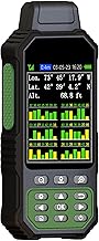
Large Screen:Large 3.2" sunlight-readable color display with 240 x 320 display pixels for improved readability,even in bright sunlight.
Professinal Accuracy: Supports 6 satellite systems (GPS, Beidou, Galileo,GLONASS, NAVIC and QZSS ) for high presion measurement, area error < 0.002 acres,distance error < 5 ft. 7 Measurement Modes: Supports area measurement of irregular and regular terrain such as ranches, garden; length measurement of straight and curved lines, height and slope measurement, and can also save the coordinate points of the current position (can only save coordinates, cannot be modified). Rugged With Long Battery Life: IP65-rated for superior durability; powered by internal 4000 mAh Li-ion rechargeable battery, up to 48 hours in continuous use. How to Use: Intuitive user interface with backlit buttons for quick and easy operation. The device needed to be held horizontal for taking measurements. Recommended to measure an area above 0.16 acres and distance above 328 ft. The larger the measurement range, the smaller the error
ZL190PLUS Land Surveying Equipment, Handheld GPS for Surveying with 3.2 Inch Color Screen, Multi-GNSS Support, 7 Measuring Models for Measuring Land Area, Length,Slope and Save Coordinates Points stays popular because award-winning • customer favorite, making it easier to compare against similar items from PrisShop.
This page focuses on the details buyers usually scan first: price position, review signal, and whether fits the current shortlist.
Recent buyer notes here make it easier to scan confidence, delivery, and fit signals before moving to another listing.
These comments add quick context around expectations, repeat purchase intent, and the type of use buyers describe most often.