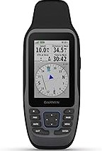
Garmin Rino 700, Rugged 2-Way Radio and Handheld GPS Navigator with GPS/GLONASS, 2.2 inches (010-01958-20)
5 w gmrs two-way radio offers extended range, up to 20 miles; communicate by voice or unit-to-unit text Messaging.Control Method:Voice.Special Feature:Bluetooth.. High-sensitivity GPS and GLONASS satellite reception; tracks in more challenging environments than
GPS alone. Position reporting feature shows locations of other Rino users on the same channel. Worldwide base map shows position and supports basic navigation. Rechargeable Internal lithium-ion battery can provide up to 13 hours of battery life. the unit’s easy-to-use thumbstick control makes one-hand operation simple
Why this pick stands out
Garmin Rino 700, Rugged 2-Way Radio and Handheld GPS Navigator with GPS/GLONASS, 2.2 inches (010-01958-20) stays popular because premium quality • guaranteed authentic, making it easier to compare against similar items from PrisShop.
This page focuses on the details buyers usually scan first: price position, review signal, and whether fits the current shortlist.
You can use this overview to compare value, positioning, and feedback before moving to the next product.
More Picks to Compare
Related Articles
★★★★★ Recent Customer Notes
These comments add quick context around expectations, repeat purchase intent, and the type of use buyers describe most often.
Recent buyer notes here make it easier to scan confidence, delivery, and fit signals before moving to another listing.