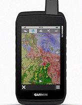
Garmin eTrex® Solar, GPS Handheld Navigator, Unlimited Battery Life, Water Resistant
The 2.2” high-contrast display is easy to read, even in bright sunlight. Get unlimit…
★★★★☆ 4.1
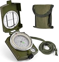
High Accuracy and Reliability: This military compass ensures precise readings, making it perfect for camping, hiking, and mountaineering..
Built to Last: Constructed with rugged materials, our compass survival is designed to withstand rough conditions, providing durability and water-resistant.. Enhanced Features for Accuracy: The lensatic compass features lensatic function, prism lens, bubble level, and clear scales offer improved accuracy and reduced errors.. Nighttime Navigation Made Easy: The fluorescent design and glow-in-the-dark interface allow for clear readings even in low-light or dark conditions. Compasses ensuring you won't get lost during nighttime adventures.. Convenient Portability: With a carrying case, lanyard, or pouch included, this compact and lightweight pocket compass is easy to transport, making it ideal for on-the-go adventures.
Compass, Hiking Compass for Survival with Lensatic – Water-Resistant Durable and Pocket-Sized stays popular because limited stock • order now, making it easier to compare against similar items from PrisShop.
You can use this overview to compare value, positioning, and feedback before moving to the next product.
Recent buyer notes here make it easier to scan confidence, delivery, and fit signals before moving to another listing.
These comments add quick context around expectations, repeat purchase intent, and the type of use buyers describe most often.